Glynn County Wills, Estates, Marriages, City Directories
Wills and Estates
- Wills & Appraisements 1809-1843
- Wills & Appraisements 1842-1849
- Images of Originals of Wills and Estates 1809 to 1845
Online Images of Wills & Appraisements 1856-1866
Indexes to Probate Records
- Wills, Inventories, Appraisements, Bk D 1810-1843
- Wills, Inventories, Appraisements, Bk D 1844-1853
Marriages
- 1818 to 1852
- 1827 to 1866
- 1885 to 1886
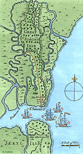
Maps
- Map of Blythe Island.
City Directories
- 1890 Brunswick
- 1892 Brunswick.
- 1892 St. Simons Island.
- 1898 St. Simons Island.
Traced Genealogies of Glynn County Families
- Couper
- Dubignon
- Harris
- Mackay
- McIntosh
- Tyson
Military Road on St. Simons Island
General Oglethorpe established a fort on the northern part of the island in 1738 and a smaller fort on the southern tip where the lighthouse was later built adjoining Military Road. The Colonial Records of Georgia by Candler describes this road as being due east and crossing Gully Hole Creek at its narrowest point. A personal visit to this area suggests that this may have been the entrance through a stockade fence leading inside the town. Also, there are several cement graves rising above the ground. Although the inscriptions are no longer discernible, the fact is (according to Candler) there were deaths occurring as early as 1741. After crossing Gully Hole Creek and the marsh, the road swung to the southeast, crossing the present (Frederica) Road to the south end just north of Obligation Pond which touched the eastern shore of St. Simons. From this point, it followed the edge of the marsh to the site of the Battle of Bloody Marsh.